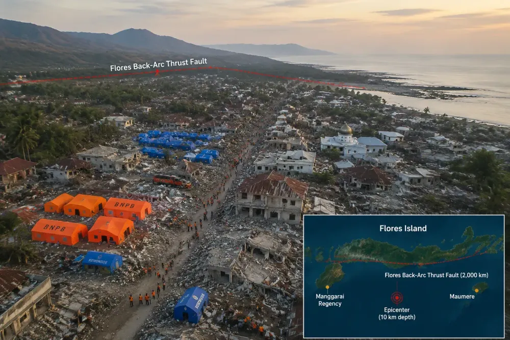
At least 53 people are dead, 135 injured and roughly 9,290 displaced after a magnitude-7.7 earthquake tore through Indonesia's Flores Island early Saturday, according to BNPB. The quake struck at 5:58 a.m. local time, August 15, 2026 just as most residents were still asleep, and has since been followed by nearly 1,000 aftershocks, a scale of seismic aftermath that has stunned even disaster officials accustomed to Indonesia's routine tremors, according to Straits Times.
The immediate trigger was straightforward: a rupture along the Flores back-arc thrust fault, a roughly 2,000-kilometer undersea structure that runs north of Indonesia's island chain and absorbs a sliver of the immense tectonic pressure building as the Australian plate grinds beneath the Eurasian plate, according to geological data compiled from the US Geological Survey and Indonesia's meteorological agency. The US Geological Survey put the quake's depth at just 10 kilometers, shallow enough to produce violent, close-range shaking rated at MMI VIII, or "severe," on the intensity scale. Germany's GFZ Helmholtz Centre recorded a slightly different reading of magnitude 7.61 at 25 kilometers depth, a normal variance between international seismic networks assessing the same event.
What makes this earthquake more than a routine natural disaster story is the fault beneath it. Geologists had already flagged the Flores back-arc thrust as capable of producing a quake up to magnitude 7.8 or 7.9, and the eastern segment of that same fault ruptured in December 1992, killing more than 2,500 people in one of the deadliest earthquakes in Indonesian history, according to historical records. Saturday's quake ruptured the fault's previously unbroken western segment, a fact that seismologists will now use to reassess risk models for the wider Lesser Sunda chain, an archipelago of roughly 17,000 islands that sits atop the Pacific Ring of Fire.
Where the deaths concentrated, and why
Nearly all of the confirmed fatalities came from just two adjoining regencies on Flores. Indonesia's National Disaster Management Agency, known as BNPB, reported 24 deaths in Manggarai Regency and 17 in East Manggarai, with the remaining deaths spread across Sikka, Ende, Ngada and West Manggarai, according to BBC Indonesia. In East Manggarai alone, 14 people died when a single building collapsed. In the port town of Maumere, two people were killed and five others injured when a maritime passenger terminal collapsed onto waiting travelers, and several people were thrown into the sea after a boarding gangway to an inter-island ferry gave way, according to Wikipedia, which compiles official incident reports.
Officials and survivors offered a grim, recurring explanation for why the death toll skewed so heavily toward one geographic cluster: timing. Because the quake struck just before 6 a.m., most victims were killed in their sleep as roofs and walls came down on top of them, East Nusa Tenggara Governor Emanuel Melkiades Laka Lena told reporters, according to Washington Post. Construction quality compounded the danger. BNPB's damage tally shows 914 homes severely damaged, 126 moderately damaged and 317 lightly damaged, along with 93 educational facilities, 36 health facilities and 38 government offices affected, according to BBC Indonesia. At a district hospital, both the operating-theater ceiling and a clinic ceiling collapsed, forcing patients including newborns to be treated in tents outside.
A shallow undersea rupture of this kind also generates tsunami risk independent of the shaking itself, and Indonesia's early-warning system activated within roughly two minutes, triggering evacuation orders across South Sulawesi, Southeast Sulawesi, East Nusa Tenggara and West Nusa Tenggara, according to BBC. Waves that followed were modest by tsunami standards but still measurable: 1.61 meters at Reok in Manggarai Regency, 0.94 meters near Ende, and smaller surges reaching as far as Buton in South Sulawesi, more than 500 kilometers from the epicenter. The warning was lifted about ninety minutes after issuance once monitoring stations confirmed the threat had passed, though roughly 2,000 residents had already fled to higher ground, and nearly 1,000 tourists were left stranded on Padar Island, a popular gateway to Komodo National Park, after maritime port operations were suspended, according to Wikipedia.
A response still racing the clock
Indonesian President Prabowo Subianto ordered an interagency response within hours, dispatching his coordinating minister for human development, the interior minister, the public works minister and the heads of both the disaster agency and search-and-rescue agency to the disaster zone, according to Antara. The government has so far sent 50,000 aid packages weighing a combined 275 tonnes, while the armed forces deployed 1,267 personnel and police sent 260 officers, including canine search teams, to comb through debris, according to Wikipedia, which cites Indonesian government statements. East Nusa Tenggara's provincial government declared a 14-day state of emergency running through August 28.
As of Sunday, search-and-rescue officials reported no confirmed missing persons across the seven affected regencies, a detail that Basarnas deputy Abdul Muhari described as meaning there is currently no active list of people still being searched for, though he cautioned that casualty figures were still being verified as the response entered its second day, according to the Star. More than 5,000 people remained in evacuation shelters, concentrated in Sikka Regency, where roughly 3,356 people gathered at a sports stadium, and in Manggarai Regency, where about 2,078 people sought shelter, according to BBC Indonesia.
Aid groups on the ground described urgent, basic shortages. A BNPB spokesman said survivors needed emergency tents, food, medicine, blankets, camp beds, mats, clean water and generators, according to AFP. World Central Kitchen said its teams were working to deliver meals to affected communities, while the International Federation of Red Cross and Red Crescent Societies said preparations were underway to bring aid to thousands sheltering in temporary sites. European Commission President Ursula von der Leyen offered to deploy the European Union's Copernicus satellite system to assist search-and-rescue coordination, writing on social media that "Europe stands ready to deploy Copernicus, our eyes in the sky, to support search and rescue efforts," according to AFP wire. Thailand placed its national urban search-and-rescue team on standby pending a formal request from Jakarta, according to Nation Thailand.
Infrastructure damage is complicating the relief effort in ways that mirror the challenges of Indonesia's 1992 disaster on the same fault segment. Landslides blocked roads between Ende and Nagekeo and between Ende and Maumere, cutting off some communities from rescue teams entirely in the immediate aftermath. Twenty of 52 fuel stations across Flores closed due to earthquake damage, threatening the movement of aid and emergency vehicles. Airport ceilings partially collapsed at Frans Sales Lega Airport in Ruteng, while facilities at Komodo International Airport in Labuan Bajo and two smaller regional airports also sustained damage, complicating the logistics of flying in additional relief supplies and personnel to one of Indonesia's more remote provincial clusters.
With aftershock activity, at 995 events and counting, expected by Indonesian seismologists to persist at an elevated rate for two to three more weeks before gradually tapering, authorities have warned residents against re-entering damaged structures, and hospitals evacuated as precautions against aftershock-triggered collapse remain only partially operational. The scale of destruction, while far below the 1992 disaster's toll, has again exposed how a single, little-monitored undersea fault can reshape the fate of an island chain that most of the world associates with tourist destinations like Komodo National Park rather than active tectonic hazard.