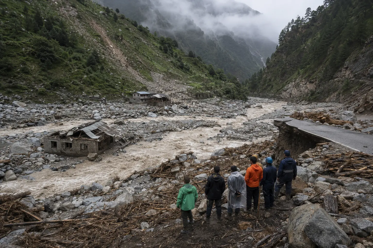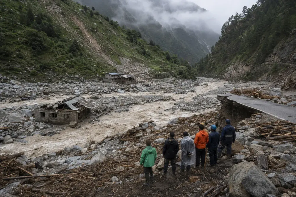
At least 160 people were confirmed dead and hundreds more were missing Wednesday after an avalanche of ice and rock unleashed a fast-moving flood across the Nepal–China border, destroying villages, roads, bridges and hydropower infrastructure in one of the Himalayas’ most consequential disasters in years.
Nepalese authorities reported 157 deaths, while Chinese state media reported three in Tibet, according to the latest AP account available late Aug. 26. More than 400 tourists, workers and residents were unaccounted for, including hundreds of foreign travelers on routes connected to Mount Kailash. Those numbers remained provisional because floodwater, thick sediment, damaged communications and blocked roads prevented rescuers from reaching some communities.
The central new finding was not only the scale of the casualties but the emerging explanation for the sudden surge. Satellite imagery examined by scientists showed that part of a glacier roughly 5,200 meters above sea level broke away and fell more than 1,200 meters into a valley, Reuters reported. The impact mobilized ice, rock, water and sediment into a destructive flow through the Bhote Koshi and Trishuli river system. Investigators had not yet established whether recent heat, a seismic disturbance or a combination of stresses initiated the collapse.
How an Ice-Rock Avalanche Became a Flood
The disaster appears to have begun as an ice-rock avalanche rather than a conventional rain-driven river flood. A collapsing mass can convert gravitational energy into heat and motion as it descends, entraining loose rock, snow and water. When that mixture enters a confined mountain channel, the valley can funnel it into a dense surge that behaves less like ordinary water than wet concrete, carrying boulders and structural debris while rapidly raising downstream river levels.
Witness evidence and remote sensing support that sequence, but the exact chain remains under review. A signal initially interpreted as a magnitude-4.4 earthquake was later assessed as consistent with a landslide or collapse. Scientists cited by Reuters said imagery showed the lower portion of a glacier missing after the event. That distinction matters: an earthquake may have triggered instability, or the collapse itself may have produced the seismic signature. Current evidence does not justify choosing between those possibilities.
The surge moved from the high border region into inhabited valleys with little time for evacuation. Water reportedly rose by as much as nine meters at some downstream points within roughly half an hour. Steep terrain intensified the velocity while narrow channels concentrated debris, exposing settlements, roads and power projects built close to river corridors. Once bridges and telecommunications failed, the same geography that accelerated the flood also slowed the response.
A Cross-Border Disaster Complicates Rescue
The missing included local residents, Nepalese police officers, hydropower workers and international visitors traveling through Nepal and Tibet. The AP reported 341 foreign nationals among those unaccounted for in Nepal, including citizens of India, the United States, Australia, Britain and Canada. China reported 265 people missing in the Tibetan border region. Because those categories were assembled by different authorities and were changing rapidly, they should not be combined into a definitive total without reconciliation.
Nepal deployed police and military teams, while China mobilized rescue personnel in the Gyirong area. Helicopters faced limited landing options, and crews used heavy equipment where roads remained passable. The IFRC and Nepal Red Cross opened an emergency response as communities were cut off. India and several governments with missing nationals began coordinating with Nepal, while downstream authorities monitored river levels and moved some residents away from vulnerable areas.
The operational problem extends beyond finding survivors. Mud and coarse debris can bury structures, contaminate water systems and change river channels, creating secondary hazards after the initial surge. Temporary blockages upstream can also fail without warning. Rescue teams therefore must balance speed against the possibility of additional flows, unstable slopes and damaged bridges, particularly while monsoon conditions continue.
Infrastructure Concentrated in the Hazard Corridor
Rasuwa’s valleys are more than settlement corridors. They carry a strategic highway connection with China and contain hydropower projects that rely on the same steep gradients that make flood energy so destructive. Damage to roads, substations and generating facilities can isolate communities and interrupt electricity even where homes survived. Rebuilding also becomes more difficult if the river has shifted or deposited deep sediment over foundations and access routes.
The disaster follows destructive flooding in the same broader border region in 2025, when a glacial lake outburst damaged the trade route and other infrastructure. Repeated losses expose a planning mismatch: fixed assets are expected to operate for decades, while mountain hazards are changing faster than historical records may capture. Engineering standards based on past river levels can underestimate compound events involving ice collapse, landslides, temporary dams and debris-rich floods.
That does not mean every road or power project in a Himalayan valley is misplaced. Mountain economies need transport, electricity and trade access, and alternative routes may be technically or financially impractical. It does mean project appraisal must account for upstream cryosphere conditions, not only rainfall and conventional flood recurrence. Monitoring must cross national borders because the initiating event can occur in one country while the most severe consequences travel downstream into another.
Warming Raises Risk but Does Not Prove Cause
The Himalayan cryosphere is changing rapidly. A March 2026 assessment by the International Centre for Integrated Mountain Development found that Hindu Kush Himalayan glaciers lost about 12% of their area and 9% of estimated ice reserves from 1990 to 2020, with wastage accelerating after 2000. Three-quarters of the region’s glaciers are smaller than 0.5 square kilometers, a class the assessment identified as especially vulnerable.
Earlier ICIMOD research found glacier disappearance was 65% faster during 2011–2020 than in the previous decade. The broader HI-WISE assessment concluded that changes in glaciers, snow and permafrost are accelerating risks to water, ecosystems and mountain societies. Warming can increase meltwater, weaken ice and permafrost, enlarge glacial lakes and expose unstable rock. Those mechanisms create conditions in which avalanches, lake outbursts and debris flows may become more likely or more damaging.
Still, regional warming trends are not proof that human-caused climate change triggered this particular collapse. Individual failures depend on glacier geometry, fractures, precipitation, temperature, bedrock and possible seismic forcing. The WMO has documented roughly 1.8 degrees Celsius of warming across the broader “Third Pole” over about half a century and identifies high temperature and heavy precipitation as important factors in glacier-debris hazards. Event attribution requires site-specific analysis that was not complete Wednesday.
The Warning Gap Is Now the Central Question
The immediate priority remains rescue and an accurate accounting of the dead and missing. After that, investigators will need to reconstruct the collapse using satellite images, seismic records, weather observations and field evidence. That analysis should determine the initiating point, the volume of material, the speed and route of the surge, and whether identifiable precursors appeared early enough for a warning.
Early-warning systems for glacial lakes are improving, but an ice-rock avalanche presents a harder monitoring problem. Sensors must detect unstable slopes or unusual glacier movement, transmit across remote terrain and connect to sirens and evacuation plans downstream. Even a technically accurate alert has limited value if settlements receive only minutes of notice, roads are scarce or authorities on opposite sides of a border do not share data in real time.
The Aug. 26 flood establishes that a high-altitude collapse can become a multinational mass-casualty event within a single river system. It does not yet establish the precise trigger or how much warming changed the odds. The next evidence that matters will be the reconciled casualty count, the mapped flood path and a transparent scientific reconstruction capable of turning this disaster into better monitoring, infrastructure design and cross-border warning.