At least 750 people have been confirmed dead and more than 3,000 remain missing after catastrophic flooding along the Nepal-Tibet border, while renewed upstream-flow warnings on Sunday forced survivors in already devastated districts to seek higher ground. Nepal’s disaster agency reported 734 deaths and 2,498 missing, and Chinese authorities reported 16 deaths and 546 missing in Tibet, according to the latest AP tally.
The new alert followed a Chinese warning to Nepal that water flow was increasing upstream in the Bhotekoshi River. Residents in Galchhi gathered on elevated bridges as flood notices reached mobile phones, four days after a mass of water, ice, rock and mud tore through the steep river corridor. The changing toll remains provisional because rescue teams are working across severed roads, unstable slopes and settlements buried under thick sediment.
The immediate emergency has become both a multinational search operation and a test of whether Nepal can prevent a second disaster while recovering from the first. More than 3,700 people have been rescued, but authorities believe over 100 may be trapped in a mud-filled tunnel at the Upper Trishuli-1 hydropower project. Nepal has requested specialized foreign assistance for tunnel rescue, survivor detection, forensic identification and the restoration of transport links.
A Collapse Became a River-Basin Disaster
The disaster began at about 8:40 a.m. Wednesday, when a massive surge entered the Bhote Koshi River in Nepal’s Rasuwa district. The government’s official appeal says floodwaters then severely affected riverbank areas in Rasuwa, Nuwakot, Dhading and Gorkha, turning a high-altitude collapse into a downstream emergency across multiple districts.
Satellite analysis indicates that bedrock and glacier ice collapsed near Langtang Lirung before the debris entered tributaries feeding the Trishuli system. The resulting flow was not ordinary river flooding: it carried enormous volumes of ice, boulders, sediment and structural debris through narrow valleys where communities, roads, power facilities and border infrastructure occupy limited flat ground. Satellite images showed the collapse scar and the widened, debris-filled channels left below it.
The International Centre for Integrated Mountain Development, or ICIMOD, describes the affected zone as the Kyirong-Rasuwa corridor linking Tibet with northern Nepal. Its event record cautions that the full extent and precise sequence will take time to establish. That distinction is important: a glacier-and-rock collapse is the leading explanation, but investigators have not yet completed the field work needed to determine how warming, permafrost degradation, recent precipitation and local geology interacted in this specific event.
Rescue Teams Face Geography and Time
Nepal has mobilized thousands of soldiers, police and emergency personnel, while helicopters have carried survivors from isolated communities and delivered food, clothing and basic supplies. The terrain limits what those resources can accomplish. Steep mountains, narrow gorges, fog and rain have repeatedly constrained flights, and destroyed bridges have divided communities from relief centers and heavy equipment.
The hardest technical problem is at the Upper Trishuli-1 hydropower site, where authorities believe more than 100 people may be trapped in a tunnel filled with mud. An Indian tunnel-rescue reconnaissance team has deployed, and a Chinese team is expected, according to current reporting. Nepal has also requested rapid DNA analysis and refrigerated morgue capacity because some recovered bodies can no longer be identified visually.
Hundreds of missing people are foreign nationals who were working, trekking or traveling toward Mount Kailash, a pilgrimage destination sacred to several religions. Chinese state media identified missing people from more than 20 countries, including Nepal, India, Latvia, the United States and Britain. Those figures are still being reconciled among governments, tour operators, employers and families, so changes in the missing count may reflect verified contact as well as rescue or recovery.
International support is moving from general offers toward specialized capabilities. Nepal said India had delivered more than 57 metric tons of relief supplies, while China, Japan, Australia and other governments were contributing equipment or assistance. The division of labor reflects Nepal’s stated position that its own forces remain in charge of the search, while foreign teams supply technical skills that are scarce locally. That model can reduce coordination problems, but its effectiveness depends on damaged roads reopening quickly enough to move heavy rescue machinery beyond helicopter landing zones.
Fresh Warnings Complicate the Response
The most urgent new development is not only the rising toll but the possibility of further flooding. Chinese monitoring showed that one lake formed after the collapse had begun draining and its level had fallen substantially, reducing one immediate threat. Authorities nevertheless identified another lake and continued round-the-clock monitoring with satellite images, drones and radar because unstable debris dams can release water suddenly.
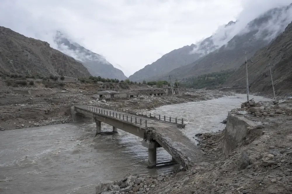
On Sunday, increased flow upstream prompted a new warning downstream. In damaged villages, repeated alarms required families with children and older relatives to move again, sometimes at night and in rain. Even a smaller secondary surge could be dangerous because the original flood altered channels, weakened slopes, deposited sediment and removed bridges that would ordinarily support evacuation and relief.
The warnings also expose the importance of rapid cross-border data sharing. Rivers descend from Tibet into Nepal faster than conventional administrative alerts can travel through damaged communications networks. Chinese notification gave Nepalese officials time to warn communities Sunday, but the disaster will intensify scrutiny of whether both countries exchange sufficiently detailed hydrological, satellite and hazard data before emergencies, not only after a collapse is underway.
Reconstruction Could Equal a Tenth of Nepal’s Economy
Nepal may need $4 billion to $5 billion to rebuild, Finance Minister Swarnim Wagle told Reuters. That initial range is not a completed damage assessment, but it is extraordinary relative to a country whose 2025 gross domestic product was about $45.5 billion, according to the World Bank. At the upper end, the estimate approaches 11 percent of annual economic output.
The cost extends beyond replacing homes. Floodwaters damaged roads, large bridges, electricity infrastructure, water systems, customs facilities and hydropower projects. The Prithvi Highway, a critical route carrying food, fuel and goods toward Kathmandu, remains only partly functional. Lost generating capacity and construction delays could compound fiscal pressure because hydropower is central to Nepal’s investment strategy and electricity exports.
The damaged Gyirong-Rasuwa crossing also carries consequences outside the immediate flood zone. It is an important overland route for bilateral commerce and for travelers moving between Nepal and Tibet. Long closure would redirect trade toward more distant crossings, raise transport costs and weaken tourism during recovery. Those second-order losses are not yet captured reliably in the government’s preliminary estimate, which means the final economic burden will depend on how quickly bridges, customs operations and dependable power can be restored.
Health risks are also shifting from traumatic injury to interrupted care, unsafe water, displacement and disease. The WHO reported three health posts destroyed, one hospital partially damaged and access to two hospitals disrupted, with roughly 10,000 households needing immediate relief. UNICEF estimated that at least 17,000 children were affected and warned of rising risks of illness, malnutrition, violence and exploitation when families lose shelter, sanitation and routine services.
Climate Risk Is Clearer Than Event Attribution
Scientists have long documented rapid change across the Hindu Kush Himalaya. ICIMOD found that glaciers disappeared 65 percent faster during 2011-2020 than in the previous decade, a regional trend it attributes primarily to rising temperatures. Its assessment warns that ice loss, thawing permafrost and changing precipitation increase the probability of cascading hazards involving rockfalls, landslides, glacial lakes and floods.
That evidence does not establish that climate change alone caused Wednesday’s collapse. Mountain failures have multiple triggers, and determining causation requires measurements of geology, ice structure, temperature, rainfall and slope stability. The defensible conclusion is narrower: warming is altering the background conditions in which Himalayan slopes and glaciers fail, making systematic monitoring and resilient infrastructure more important even when attribution for an individual event remains incomplete.
The immediate record establishes a disaster still expanding in human and economic terms. The confirmed toll has reached 750, the missing count exceeds 3,000, and survivors remain exposed to fresh water surges and severed services. What follows will depend first on locating trapped people and keeping downstream communities safe, then on whether Nepal, China and international partners can rebuild transport, health and energy systems for a mountain environment whose hazards are changing faster than older designs assumed.